SpecialK's Gallery
Vacations
Bishop-D Valley 08
3 Bish LoneP Badwtr
https://specialk.slickpic.com/albums/3BishLonePBadwtr/photo/#3980058
080326-4857SofKeoughSprMoon Heading back south, south of Keough Springs.
https://specialk.slickpic.com/albums/3BishLonePBadwtr/photo/#3980059
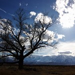
080326-4859LonePineTreeSign Just coming into Lone Pine is this tree and info sign. The tree is a pendunculate oak tree from Sherwood forest, England, and was planted as a sprout about 1900, here on the old Harvey Ranch.
https://specialk.slickpic.com/albums/3BishLonePBadwtr/photo/#3980060
080326-4860LonePineRoadSign
https://specialk.slickpic.com/albums/3BishLonePBadwtr/photo/#3980061
080326-4861LonePineErthqkCemSign
https://specialk.slickpic.com/albums/3BishLonePBadwtr/photo/#3980062
080326-4862LonePineCemMrkr
https://specialk.slickpic.com/albums/3BishLonePBadwtr/photo/#3980063
080326-4863LonePineErthqkCem This is a little cemetery honoring the 27 victims of a major earthquake in the area on March 26,1872
https://specialk.slickpic.com/albums/3BishLonePBadwtr/photo/#3980064
080326-4866LonePineCem Diagonally across the street is this 'normal' cemetery.
https://specialk.slickpic.com/albums/3BishLonePBadwtr/photo/#3980066
080326-4868DolomiteMines Now headed toward Death Valley on Hwy 136 on the east side of Owens Lake. Actually, I'm on Dolomite Loop which runs mostly parallel to Hwy 136 through the town of Dolomite (now gone?).
https://specialk.slickpic.com/albums/3BishLonePBadwtr/photo/#3980067
080326-4871DolomiteMrkr This marker says the dolomitic limestone mines are still in operation and in fact are the largest in the US. Found in 1862, the remote location delayed actual mining operations until 1885.
https://specialk.slickpic.com/albums/3BishLonePBadwtr/photo/#3980069
080326-4872DolomiteMrkr
https://specialk.slickpic.com/albums/3BishLonePBadwtr/photo/#3980070
080326-4873KeelerRdSign Keeler.
https://specialk.slickpic.com/albums/3BishLonePBadwtr/photo/#3980071
080326-4875KeelerIntersection Hwy 136 seems old enough. Apparently there is another, older one.
https://specialk.slickpic.com/albums/3BishLonePBadwtr/photo/#3980072
080326-4876KeelerWall What looks like a building in the previous shot is just a wall now.
https://specialk.slickpic.com/albums/3BishLonePBadwtr/photo/#3980073
080326-4877KeelerBeach As the slightly sarcastic, though accurate, note on the surfboard says, 'the beautiful setting is provided by the LA water district' which diverted most of the water to the Los Angeles region.
https://specialk.slickpic.com/albums/3BishLonePBadwtr/photo/#3980074
080326-4879KeelerBldg Keeler stamp mill.
https://specialk.slickpic.com/albums/3BishLonePBadwtr/photo/#3980075
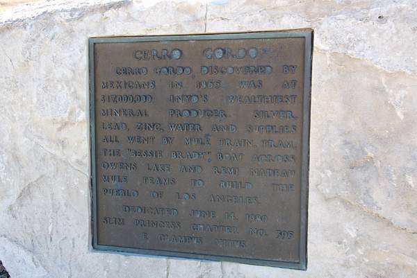
080326-4881CerroGordoPlaque
https://specialk.slickpic.com/albums/3BishLonePBadwtr/photo/#3980078
080326-4883ElectricRepair Working on the power lines near Keeler.
https://specialk.slickpic.com/albums/3BishLonePBadwtr/photo/#3980079
080326-4885DarwinMrkr
https://specialk.slickpic.com/albums/3BishLonePBadwtr/photo/#3980081
080326-4890PadreCrowleyPlaque
https://specialk.slickpic.com/albums/3BishLonePBadwtr/photo/#3980082
080326-4893CrowleyPtShadow Me and my shadow looking toward Rainbow Canyon at Crowley Point.
https://specialk.slickpic.com/albums/3BishLonePBadwtr/photo/#3980083
080326-4895CrowleyPtPeople I think these are the German tourists who asked me to take a picture of them with their camera.
https://specialk.slickpic.com/albums/3BishLonePBadwtr/photo/#3980084
080326-4897CrowleyPtView Crowley Pt view.
https://specialk.slickpic.com/albums/3BishLonePBadwtr/photo/#3980085
080326-4898PanamintSprSign This is about 1/4 of Panamint Springs.
https://specialk.slickpic.com/albums/3BishLonePBadwtr/photo/#3980086
080326-4899PanamintSprCafe This is the main/only restaurant. Just down the road, the only gas station was selling gas for $5.39 a gallon.
https://specialk.slickpic.com/albums/3BishLonePBadwtr/photo/#3980087
080326-4900StovepipeWellsCtr Stovepipe Wells is one of the large, touristy areas of Death Valley.
https://specialk.slickpic.com/albums/3BishLonePBadwtr/photo/#3980089
080326-4901BurnedwgnsPtMrkr
https://specialk.slickpic.com/albums/3BishLonePBadwtr/photo/#3980090
080326-4902BurnedWagonsPt Not sure if the firetruck is part of it, but this is 'Burned Wagons Point', across the street from the Stovepipe Wells center. In 1849, some of the Jayhawk group burned their wagons, killed some oxen for food, and continued on foot out of the valley.
https://specialk.slickpic.com/albums/3BishLonePBadwtr/photo/#3980091
080326-4903StovepipeWellsRngrStn This is the ranger station at Stovepipe Wells, where I paid my $20 entrance fee.
https://specialk.slickpic.com/albums/3BishLonePBadwtr/photo/#3980092
080326-4906StovepipeWellsDunes Two miles down the road are the Stovepipe Wells dunes.
https://specialk.slickpic.com/albums/3BishLonePBadwtr/photo/#3980095
080326-4909DevilsCornfield Near the same location are these plants in an area known as 'The Devil's Cornfield'.
https://specialk.slickpic.com/albums/3BishLonePBadwtr/photo/#3980096
080326-4913SofWell On a road to the actual Stovepipe Wells is this bit of history. The tracks parallel the edge of the lighter-colored sand.
https://specialk.slickpic.com/albums/3BishLonePBadwtr/photo/#3980097
080326-4916StovepipeWell It should be 'Stovepipe Well' as there is only one. When the shifting sands started to obliterate the well, a length of stovepipe was jammed into it as a marker.
https://specialk.slickpic.com/albums/3BishLonePBadwtr/photo/#3980098
080326-4918StovepipeWellMrkr
https://specialk.slickpic.com/albums/3BishLonePBadwtr/photo/#3980099
080326-4919StovepipeWell Boarded up now. The skull is a nice bit of tourist attraction.
https://specialk.slickpic.com/albums/3BishLonePBadwtr/photo/#3980101
080326-4920StovepipeWell The fitting comes from Indiana.
https://specialk.slickpic.com/albums/3BishLonePBadwtr/photo/#3980103
080326-4923SofSaltCrkFlowers South of Salt Creek was this sign of life.
https://specialk.slickpic.com/albums/3BishLonePBadwtr/photo/#3980105
080326-4924BoraxWorksPlaque
https://specialk.slickpic.com/albums/3BishLonePBadwtr/photo/#3980106
080326-4925BoraxWorks This is the Harmony borax works.
https://specialk.slickpic.com/albums/3BishLonePBadwtr/photo/#3980107
080326-4927BoraxWorks More of the borax works.
https://specialk.slickpic.com/albums/3BishLonePBadwtr/photo/#3980108
080326-4928BoraxWorksPlaque One of the info plaques has this photo of how it was when it was.
https://specialk.slickpic.com/albums/3BishLonePBadwtr/photo/#3980109
080326-4929BoraxWorksPlaque
https://specialk.slickpic.com/albums/3BishLonePBadwtr/photo/#3980110
080326-4930BoraxWorks
https://specialk.slickpic.com/albums/3BishLonePBadwtr/photo/#3980111
080326-4931BoraxWorksPlaque
https://specialk.slickpic.com/albums/3BishLonePBadwtr/photo/#3980113
080326-4932BoraxWorks
https://specialk.slickpic.com/albums/3BishLonePBadwtr/photo/#3980114
080326-4934BoraxWorksPlaque
https://specialk.slickpic.com/albums/3BishLonePBadwtr/photo/#3980115
080326-4935BoraxWorksPlaque
https://specialk.slickpic.com/albums/3BishLonePBadwtr/photo/#3980117
080326-4936BoraxWorksWagons Visitors read the info about the wagons.
https://specialk.slickpic.com/albums/3BishLonePBadwtr/photo/#3980118
080326-4937BoraxWorksPlaque
https://specialk.slickpic.com/albums/3BishLonePBadwtr/photo/#3980119
080326-4938FurnaceCrWagons
https://specialk.slickpic.com/albums/3BishLonePBadwtr/photo/#3980121
080326-4940GoldenCynEntr This is the entrance to Golden Canyon.
Scroll To Top
Audio Mute
Prev
Play
Next
Shuffle
Include
This site uses cookies to enhance your browsing experience, serve personalized content, and analyze traffic. By continuing to use this site you agree to
use of cookies and stewardship of your data .


