2 Rcrst AlHlls Mnz Lws by SpecialK
×
  1. SpecialK's Gallery
  2. Vacations
  3. Bishop-D Valley 08
  4. 2 Rcrst AlHlls Mnz Lws2 Rcrst AlHlls Mnz Lws
1 V'ville-Rburg-Trona
2 Rcrst AlHlls Mnz Lws
3 Bish LoneP Badwtr
4 Pah Arm ZPt Sho Bar
5 Bars OroG Vvil
Early morning in Ridgecrest.
West of Ridgecrest on Hwy 395. Sunrise coming...
Near Pearsonville, this was a grab-shot through the window.
This is near Little Lake.
This is the cliff at Little Lake. In the 1920's and '30's, there were some hotels and other buildings in the area. All gone.
Another hill at Little Lake.
This is the only building I saw.
Not far up Hwy 395 is this volcanic cinder cone.
Just off Cinder Rd is the road to Fossil Falls. I'm on the short lava-strewn trail looking back to the cinder cone.
No fossils, no falls :-) The lava which has been weathered into these odd shapes, drops off to a 50-foot high gully in the middle of the shot.
Sort of an art shot.
I've travelled 4 miles on a ratty dirt road to get here - the handicapped parking spot for....
The scenic Little Lake Overlook, with its information panels.
And the view of Little Lake and the cinder cone.
This is Big Pine Distributors on the outskirts of Olancha.
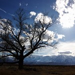
On a dirt road on the way to the Big Pine Distributors is this ruin of a siding. The mountains are getting larger and closer, and more snow is evident.
I love this sign.
This dog chased my car and tried to bite it as I slowly drove by.
Looking back toward the siding and the California aquaduct.
Looking across Olancha toward the mostly-dry Owen's Lake.
The Olancha 'No Trespassing' School.
The Crystal Springs water plant just north of Olancha.
South of Cartago is this abandoned cafe and (I assume) house.
Not far up the road is this field. The historical marker has had the bronze plaque stolen.
The view of Owen's Lake from south of Bartlett. Just after getting back into my car, a highway patrolman stopped to ask if I was OK :-)
These are the Cottonwood charcoal kilns, just over the hill from the lake.
This has been identified as the PPG plant, near Bartlett.
South of Lone Pine was this flock of circling birds.
I wanted to take the zig-zag road to Horseshoe Meadows, but the ranger said it was gated pretty low down, as was Whitney Portal and other roads up the mountains.
Just as well I didn't head up the mountain as I still had places to go and explore.
This bus was in the parking lot between Carl's Jr restaurant and a small park. After a quick bite to eat, I'm off to...
The Alabama Hills, named after a Confederate ship that sank during the Civil War. This rock is known as Miss Alabama.
The Sierra Nevada mountains from the Alabama Hills.
This is on the south side of Whitney Portal Rd.
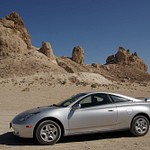
Movie Rd leads through the area of the Alabama Hills known as Movie Flats because it is featured in many Western movies and TV shows. This view is in the opposite direction, though :-)
Some arches or rocks are individually named. This area is about a mile from the road intersection, where I thought I would find the One Mile arch, but didn't...
Still, it was a neat area.
;
Scroll To Top

Audio Mute
Prev
Play
Next
Shuffle
Include
Privacy and cookie policy
This site uses cookies to enhance your browsing experience, serve personalized content, and analyze traffic. By continuing to use this site you agree to use of cookies and stewardship of your data.